Sponsored by:
Texas Association of Environmental Professionals (TAEP)
TAEP is the premier organization for environmental
professionals in the State of Texas. The goals of TAEP include
the advancement of the environmental profession and the
establishment of a forum to discuss important environmental
issues. TAEP members receive a 10% discount. Please call
713.522.6300 for the code.
GSI’s modeling professionals provide consulting and engineering services to public and private clients facing important water resources challenges across the United States and abroad. Our boutique modeling capabilities include a wide range of analyses including water supply reliability and optimization; fate and transport modeling in groundwater and surface water; climate change impact analyses, unique modeling applications (saltwater intrusion, integrated surface-water / groundwater modeling, multiphase flow and transport, subsurface vapor flow analyses, vadose zone evaluations, subsidence predictions, mine development and tailings management, flood forecasting, impact of climate change, etc.), data science techniques, research and development; and training.
Our approach has focused on developing and using models to address client specific problems, evaluate uncertainty, optimize operations, and maximize impacts of further data gathering efforts. We focus on using models and other numerical tools that are designed to meet specific project objectives. Our experts often develop models and other numerical methods in-house to fill gaps in our modeling toolchest. For example, our staff participated in or have been at the forefront in the development of Biochlor, Bioscreen, MAROS, MODFLOW-USG, Mann-Kendall Toolkit, Mas Flux Toolkit, and Matrix Diffusion Toolkit.
GSI developed a numerical model to simulate the impact of brackish groundwater pumping on surface-water, water quality, and potential for subsidence in the LRGV basin. Alternate geologic conceptualizations, uncertainty in impacts of geologic faults, and impact of data-gaps were considered in evaluation of migration behavior of saltwater and estimated chloride concentrations of extracted water to evaluate options for appropriate treatment.
GSI conducted NAPL mobility modeling in a GIS setting to provide NAPL flux estimates across the property boundary of an Oil Terminal site. A customized model was developed using the American Petroleum Institute (API) LNAPL mobility equations in a GIS framework to compute spatial distributions of LNAPL mobility, extractable volumes and residual LNAPL saturations to assist with property management.
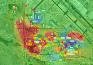
GSI applied data science methods to extract pumping response information from pump-and-treat data. The condensed information was used in inverse modeling to depict the spatial distribution of high and low hydraulic conductivity regimes, which are important for locating major flow pathways and residual contaminant mass.
Related services include: